NATURAL HERITAGE

Photo Credit: Scott Koberg
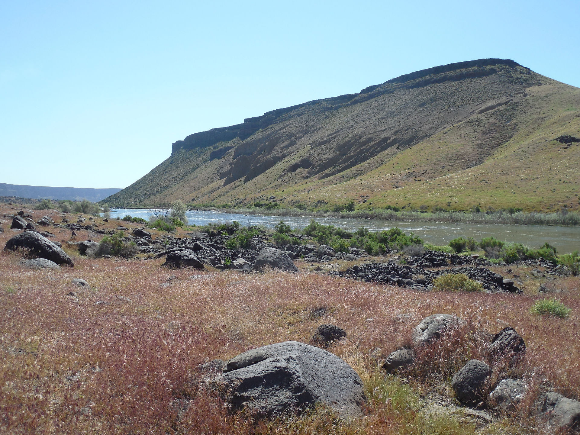
Geology
Boating, floating, or paddling the Idaho-Oregon Snake River Water Trail is a voyage at the foot of supervolcanoes, a trek down the path of one of the largest floods in the history of the planet, and a trip through a landscape of lava bombs, melon gravels, and welded spatter. The origin of the western Snake River Plain dates back about 12 million years with volcanic activity associated with the Bruneau-Jarbidge Eruptive Center, the third of seven supervolcanoes in the history of the Snake River-Yellowstone hotspot. These eruptions created a geomorphology that would fault, created a tectonic graben, or rift valley. This rift valley stretches from Glenns Ferry, Idaho, to Huntington, Oregon.
Our graben held ancient Lake Idaho 9 million years ago. For the next 7 million years, Lake Idaho filled and emptied. Rain and snow fed rivers that flowed into Lake Idaho, bringing with them sediment from the mountains. Sediments formed underlain strata and contributed to the deep soils of our wide western Snake River Plain. Ancient Lake Idaho vanished about 2 million years ago. However, another (slightly less ancient) lake played a key role in the geology of the Snake River Plain. About 15,000 years ago, western North America was characterized by very large lakes created by the periodic melting of glaciers. One of the largest of these was Lake Bonneville, of which Utah's Great Salt Lake is only a remnant.
At its largest, Lake Bonneville was about the size of Lake Michigan. A series of lava flows in eastern Idaho diverted the Bear River into the Lake until it overfilled and crested at Red Rock Pass, near Preston, Idaho. Red Rock Pass, composed of soft sedimentary layers, eroded quickly beneath the flooding lake water-- until finally it completely gave way. Lake Bonneville spilled catastrophically through the pass and swept westward along the Snake River drainage. The Bonneville Flood lasted for six weeks, and during that time 380 cubic miles of water rushed down the Snake River. This torrent, reaching speeds of 70 miles per hour, did not carve the Snake River Canyon much deeper. Instead, it scoured the canyon rims, creating massive waterfalls, and widening tributaries and gorges. Boulder fields, like those at Celebration Park, are among the most identifiable traces of the Bonneville Flood. The flood tore immense chunks of basalt from the canyon walls and tumbled them downstream for miles, giving them their rounded shape. These boulders are known as the "Bonneville Flood Melon Gravel."

Photo Credit: Scott Koberg
The Snake River: A Natural History
The Parting of the Waters
Snow on the ridge that forms the Continental Divide along Two Oceans Plateau in Yellowstone National Park melts to create North Two Ocean Creek. As it flows south it squarely hits the ridge that forms the summit of Two Oceans Pass where it splits in two. Water from this creek is sent down each side of the Divide, half destined for the Snake River and the Pacific Ocean and half destined for the Yellowstone, Missouri and Mississippi Rivers to the Atlantic.
Spring snow melt from the Two Oceans Plateau in Yellowstone National Park give rise to the Snake and Missouri Rivers. Together, they constitute over 5,000 miles of North American rivers flowing into two oceans. Rills of Wyoming runoff destined to be the Snake River capture each other, filling Jackson Lake in Grand Teton National Park. Lake water spills through Jackson Hole, flows west through Wyoming's Snake River Canyon and exits at Alpine Junction. Idaho catches the Snake at Palisades Reservoir.
As the Snake River Flows west it captures the Henry's Fork, the Teton River, the Portneuf River and the Raft River. On its lower course it captures the Bruneau River, the Malad River, the Boise River--and the Malheur, Payette, Weiser, and Burnt Rivers. Following its confluence with the Salmon, Grande Ronde and Clearwater Rivers, the Snake joins the Columbia River on its way to the Pacific Ocean. The Snake River flows 1,040 miles through four western states. Its watershed drains about 108,000 square miles, carving the deepest canyons in North America.

Vegetation
Plant communities of the upper (eastern) reaches of the Water Trail are typically arid, shrub-steppe plains and hills, and basalt-capped buttes. The Snake River is flanked by foothills to the north and south, and by the Magic and Treasure Valleys to the east and west. The rangelands are highly invaded by cheatgrass, but also contain native shrubs such as sagebrush (Artemisia tridentata) and antelope bitterbrush (Purshia tridentata). Native grasses are rare and vegetation regenerative capacity is slow due to limited moisture.
The vegetative communities on the rolling hills, benches, alluvial fans, and scattered badlands of Owyhee County (the south banks of the Snake River from Glenns Ferry to Homedale) are characteristically underlain by sandy, alkaline soils. Perennial streams are rare, and native vegetation is dominated by Wyoming big sagebrush and associated grasses, such as bluebunch wheatgrass (Pseudoroegneria spicata), Sandberg's bluegrass (Poa secunda), Thurber's needlegrass (Achnatherum thurberianum), and Indian ricegrass (Oryzopsis hymenoides). Cheatgrass and crested wheatgrass (Agropyron cristatum) are also common. Salt-tolerant shrubs, such as black greasewood (Sarcobaetus vermiculatus) and fourwing saltbush (Atriplex canescens) are also widespread.
The lower (western) reaches of the Water Trail are characterized by an unglaciated rolling valley reticulated by canals and incised rivers. The valley is underlain by Quaternary alluvium, loess, lacustrine, and alluvial deposits. Soils are arid, and supported native sagebrush-steppe communities prior to agricultural conversion. Canals and diversions in this stretch of the Snake River Plain supply water to pastureland, agricultural fields, and nearby population centers. Crops include wheat, sugar beets, alfalfa, potatoes, onions, numerous seed crops, hops and vineyards. Outside of agricultural areas is characterized by Wyoming big sagebrush, Sandberg's bluegrass, Great Basin Wild Rye (Elymus cinereus), Thurber's needlegrass, and rabbitbrush (Chrysothamnus viscidiflorus). Greasewood and fourwing saltbush occur in saline areas. Cheatgrass and other invasive annuals also dominate large swaths of undeveloped land.

Wildlife
The Snake River below Shoshone Falls is home to thirty-five native fish species, four of which are endemic to the Snake River: the relict sand roller (Percopsis transmontana), the shorthead sculpin (Cottus confusus), the marginated sculpin (Cottus marginatus), and the Oregon chub (Oregonichthys crameri). The Oregon chub is also found in the Umpqua River and nearby basins. The lower Snake River also supports seven species of salmon (Oncorhynchus). There are also high, often localized levels of mollusc endemism, especially in Hells Canyon and the basins of the Clearwater River, Salmon River, and middle Snake River. The mollusc richness extends into the lower Columbia and tributaries such as the Deschutes River.
Aside from aquatic species, much of the Snake River watershed supports larger animals including numerous species of mammals, birds, amphibians and reptiles. Pronghorn antelope and bighorn sheep are common in the area drained by the lost streams of Idaho, several rivers and creeks that flow south from the Rocky Mountains and disappear into the Snake River Aquifer. About 274 bird species, some endangered or threatened, use the Snake River Watershed as habitat, including bald eagle (Haliaeetus leucocephalus), peregrine falcon (Falco peregrines), whooping crane (Grus americana), greater sage grouse (Centrocercus urophasianus), and yellow-billed cuckoo (Coccyzus americanus). Barrow's goldeneye (Bucephala islandica) also occurs commonly along the lower section of the Snake River.
Ten amphibian and twenty reptile species inhabit the upper Snake River's wetland and riparian zones. Several species of frogs are common in the "Lost Streams" basin and the northeastern part of the Snake River Watershed, including the inland tailed frog (Ascaphus montanus), Northern leopard frog (Rana pipiens), Columbia spotted frog (Rana luteiventris), western toad (Anaxyrus boreas), long-toed salamander (Ambystoma macrodactylum), and spadefoot toad (Scaphiopus couchii). However, in the lower and middle portions of the Snake River watershed, several native species have been severely impacted by agricultural practices and the non-native species which take advantage of human modifications to the environment. Common introduced birds include the gray partidge (Perdix perdix), ring-necked pheasant (Phasianus colchicus), and chuckar (Alectoris chuckar). Other notable non-native species include the bullfrog (Rana catesbiana), the brown-headed cowbird (Molothrus ater), and the European starling (Sturnus vulgaris), attracted by the construction of cities and towns.